|
Catalog | Order | Support | SiteIndex | Contact | Home | |||||||
|
Catalog | Order | Support | SiteIndex | Contact | Home | |||||||
Technical Specification
Mountain High Maps is published as a collection of map portfoilios, and is available for use on computers running Macintosh OS or Windows and Unix or SGI platforms environments.
The Mountain High Maps collection contains:
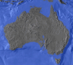
1. 78 high-resolution (300ppi), relief maps in four variations of colorization, plus vector paths and a variety of bitmap masks. The high resolution maps are all identified by the suffix ".JPG" or ".TIFF" as in "1.01 Africa-base.JPG". The relief maps feature ocean floor relief as well as land relief. These are identified as follows:
Number: each map and all masks relating to that map are prefixed by a number, as in "1.01 Africa"
Colorized maps, physical "A" (land and ocean floor relief colorized according to elevation): "PHA.JPG" as in "1.01 Africa-PHA.JPG"
Colorized maps, physical "B" (land and ocean floor relief colorized according to vegetation): "PHB.JPG" as in "1.01 Africa-PHB.JPG"
Colorized maps, political (land relief colorized according to international boundaries): "POL.JPG" as in "1.01 Africa-POL.JPG"
Base relief maps (land and ocean floor relief in grayscale): "base.JPG" as in "1.01 Africa-base.JPG" on Macintosh
Masked relief maps (land relief in grayscale, with white ocean areas): "mkd.TIFF" as in "1.01 Africa-mkd.TIFF"
2. 39 high-resolution (300ppi), globe views with corresponding ocean/land bitmap masks, identified as follows:
Grayscale globes (land relief with oceans white, TIFF format): "mkd.TIFF" as in "7.04/0-135E/mkd.TIFF"
Colorized globes (15 globes with fully colorized land relief and blue oceans, JPEG format): "COL.JPG" as in "7.04/0-135E/COL.JPG"
3. Five full-color backgrounds of the stellar sky for use with the globes, plus a cloud mask for adding a touch of realism.
4. Low-resolution (72ppi) versions of all of the relief maps and masks, in JPEG format. These are identified by "L.JPG" as in "1.01 Africa-base L.JPG"
5. Corresponding outline versions of the maps (not globe views) in Adobe Illustrator eps format. These are identified by the suffix ".eps". The Illustrator files provide fully-editable outlines of each map, with each country placed on a separate layer for easy location and editing. Additional layers include rivers, major cities, graticules (lines of latitude and longitude), and scales. All long paths are split into smaller chunks - although Illustrator allows documents to have paths with more than 1,000 points, it will not print any fills applied to those paths, so areas with colored fills have been "tiled" to assist in printing. The Illustrator files also include a layer onto which the corresponding relief maps can be placed.
6. 38 animated globes in QuickTime® format on Macintosh or .MOV and .AVI format for Windows, plus the Strata Vision 3d™ files (on Macintosh only) and supporting texture maps used to create them.
7. View Catalog containing useful technical information about the maps.
8. Hints & Tips files containing advice on using the maps with some of the most popular applications. These appear on each disc.
9. A selection of chevron arrows in Illustrator formats, for adding graphically dramatic flow lines to your maps.
The \Illustrator file formats provide fully-editable outlines of each map, with each country placed on a separate layer for easy location and editing. Additional layers include rivers, major cities, physical features, graticules (lines of latitude and longitude), and scales. The Illustrator files can be placed directly into any word-processing or page layout application which accepts the EPS file format.
The TIFF images are best used with image-editing applications such as Adobe Photoshop but they can also be used within page layout and drawing applications, where color can be applied directly.

