|
MapCatalog | Order | Support | SiteIndex | Contact | Home | ||||||||||
|
|
|
|
|
|
|
|||||||||||
| World | Polar | 605 | ||||||||||||||

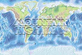
Mountain High Maps Catalog - World Gall large projection
Map Specifications for World Gall large projection
| Map identification: | 605 | Projection system: | Gall |
| Map coverage: | World Gall large projection | North boundary: | |
| Image size (pixels): | 5,132 x 3,480 pixels | South boundary: | |
| Image size (inches): | 17.11 x 11.60 inches | East boundary: | |
| Image size (metric): | 435 x 295 millimeters | West boundary: | |
| Resolution per pixel: | 6,000 meters | Horizontal scale: | 1:25,090,560 |
| RGB file size: | 51.0 Mb | Vertical scale: | 1:1,000,000 |
| CMYK file size: | 68.2 Mb | Vertical interval: | 305 meters |
| Grayscale file size: | 17.0 Mb | Vertical exaggeration: | 25.1 times normal |
|
Countries, states and territories: |
All Countries - Afghanistan, Africa, Alaska, Albania, Algeria, America, Andorra, Angola, Antarctica, Arctic, Argentina, Armenia, Asia, Atlantic Ocean, Australia, Austria, Azerbaijan, Balkans, Bangladesh, Belarus, Belgium, Belize, Benin, Bhutan, Bolivia, Bosnia-Herzegovina, Botswana, Brazil, British Isles, Brunei, Bulgaria, Burkina Faso, Burma, Burundi, Cambodia, Cameroon, Canada, Caribbean, Central African Republic, Central America, Central Asia, Chad, Chile, China, Colombia, Congo, Costa Rica, Croatia, Cuba, Cyprus, Czech Republic, Denmark, Djibouti, Dominican Republic, Ecuador, Egypt, El Salvador, England, Equatorial Guinea, Eritrea, Estonia, Ethiopia, Europe, European Union, Falkland Islands, Fiji, Finland, France, French Guiana, Gabon, Gambia, Gaza Strip, Georgia, Germany, Ghana, Greece, Greenland, Guatemala, Guinea, Guinea-Bissau, Guyana, Haiti, Hawaiian Islands, Honduras, Hong Kong, Hungary, Iberia, Iceland, India, Indian Ocean, Indonesia, Iran, Iraq, Ireland, Israel, Italy, Ivory Coast, Jamaica, Japan, Jordan, Kazakhstan, Kenya, Kuwait, Kyrgystan, Laos, Latvia, Lebanon, Lesotho, Liberia, Libya, Liechtenstein, Lithuania, Luxembourg, Macedonia, Madagascar, Malawi, Malaysia, Mali, Malvinas Islands, Mauritania, Mauritius, Mediterranean, Mexico, Moldova, Monaco, Mongolia, Morocco, Mozambique, Nagorno Karabakh, Namibia, Nepal, Netherlands, New Guinea, New Zealand, Nicaragua, Niger, Nigeria, North America, North Korea, Northen Ireland, Norway, Oman, Pacific Ocean, Pakistan, Panama, Papua New Guinea, Paraguay, Peru, Philippines, Poland, Portugal, Puerto Rico, Qatar, Romania, Russia, Rwanda, Saudi Arabia, Scandinavia, Scotland, Senegal, Sierra Leone, Slovak Republic, Slovenia, Solomon Islands, Somalia, South Africa, South America, South Korea, Spain, Sri Lanka, Sudan, Surinam, Swaziland, Sweden, Switzerland, Syria, Taiwan, Tajikistan, Tanzania, Thailand, Togo, Trinidad & Tobago, Tunisia, Turkey, Turkmenistan, U.S.A., Uganda, Ukraine, United Arab Emirates, United Kingdom, Uruguay, Uzbekistan, Vanuatu, Venezuela, Vietnam, Wales, West Bank, Western Sahara, World Gall, World Van de Grinten, Yemen, Yugoslavia, Zaire, Zambia, Zimbabwe |
||
|
| ||
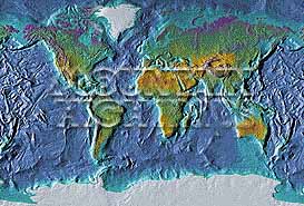
| Elevation low-contrast relief rendering View Vector + Relief map details Caution: large files in excess of 500 kb |
Vegetation high-contrast relief rendering View Vector + Relief map details Caution: large files in excess of 500 kb |
||

|

| ||
|
Top left: Elevation low-contrast relief rendering Top right: Vegetation high-contrast relief rendering Middle left: Grayscale land-only relief rendering Middle right: Political low-contrast relief rendering Lower right: Geo-political vector Illustrator EPS maps Illustrator World vector EPS preview/detail map Inventory of maps and masks within each map portfolio
|
 Illustrator USA vector EPS preview/detail map |

| World Gall Map #605 - Buying Options |
||||||||
|
World Gall (Large) Vector only EPS map (bottom left map image) |
World Gall (Large) Relief/Vector Map (all maps on this page) |
World Ocean Polar Relief/Vector 14 Map Package |
Mountain High Maps Relief/Vector 78 Map Package | |||||
Any comments or problems with this
site? Please
let us know
- thank you!
© Digital Wisdom, Inc.